EQUIPMENT AND DATASETS- MALDIVES SUMMER SCHOOL
UNCREWED AERIAL VEHICLES
Uncrewed Aerial Vehicles (UAVs), commonly known as drones, are aircraft operated remotely without a pilot onboard. In coastal mapping, UAVs are equipped with advanced sensors and high-resolution cameras to capture detailed imagery and data of shorelines and coastal features. These aerial surveys provide precise, up-to-date insights into coastal erosion, habitat changes, and environmental dynamics. By offering efficient and accurate monitoring, UAVs play a crucial role in environmental management, disaster response, and scientific research, helping experts track and analyze coastal changes with unprecedented detail.
During the Summer School, students worked in groups to plan and conduct aerial surveys under the expert guidance of the UNIMIB and Orthodroneteams. Field activities focused on data acquisition over coastal and shallow water areas surrounding Magoodhoo Island, with the goal of capturing high-resolution imagery to be seamlessly integrated with underwater data for a comprehensive reef environment model. In the laboratory session, students were introduced to the fundamentals of photogrammetry data processing, using Agisoft Metashape to generate and analyze 3D models from the collected aerial images.

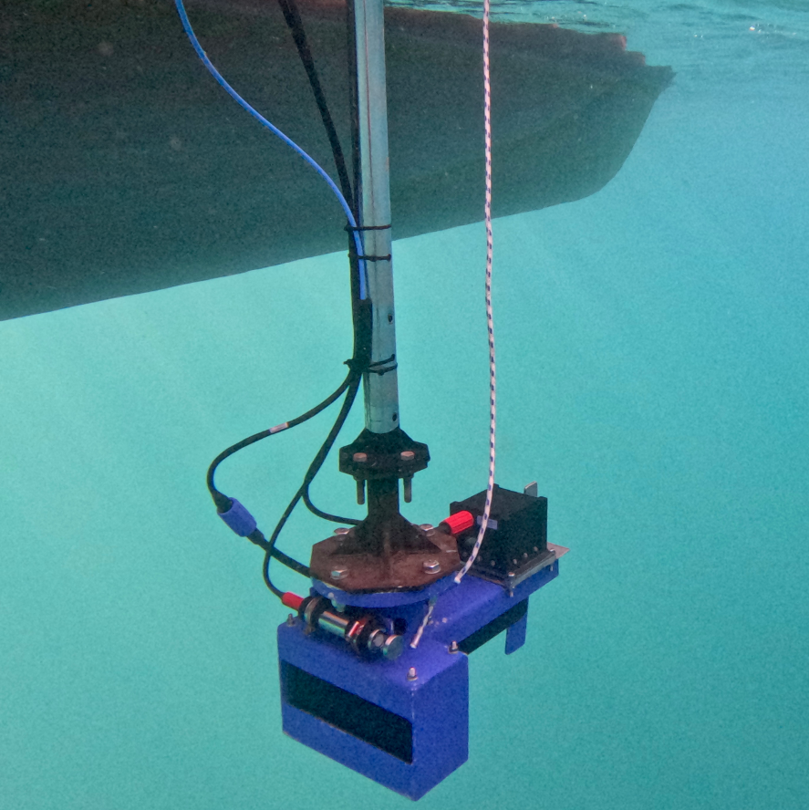
MULTIBEAM ECHOSOUNDER
The R2Sonic 2022 is a high-performance Multibeam Echosounder (MBES) designed for precise underwater mapping and surveying. Utilizing advanced sonar technology, it generates highly detailed 3D models of the seafloor. Its variable swath width capability allows users to adjust beam angles, optimizing coverage based on survey needs. Additional advanced features include real-time water column imaging, automated data processing, integrated data quality control tools, and an optional multispectral mode for enhanced analysis. Built with a rugged, compact design, the R2Sonic 2022 is ideal for deployment across various vessels and survey operations.
The students had the opportunity to observe the UNIMIB MBES in action, collecting data from the deeper areas of the coral reef using QPS Qinsy software aboard the MaRHE Center's Research Vessel, the Dhoni—a traditional wooden sailing vessel. This hands-on experience continued with a dedicated laboratory session, where students processed the collected data using QPS Qimera to create detailed Digital Terrain Models (DTMs) of the surveyed areas. We extend our sincere gratitude to QPS for their generous sponsorship, providing trial licenses to all students and enabling these valuable learning activities.
REMOTELY OPERATED VEHICLE
The future of ocean research and exploration is increasingly driven by robotics, with Remotely Operated Vehicles (ROVs) playing a crucial role. ROVs are uncrewed, tethered underwater robots controlled by operators from a surface vessel. Equipped with high-definition cameras, robotic arms, and advanced sensors, they enable scientists to explore depths and environments that are otherwise inaccessible to humans. They offer real-time control and intervention, making them ideal for deep-sea research and environmental monitoring. Their ability to operate continuously and with precision makes them indispensable tools for modern ocean exploration.
During the Summer School's dedicated field activity, participants had the unique opportunity not only to observe UNIMIB's SEAMOR Steelhead inspection-class ROV in action but also to pilot it themselves. Thanks to its lightweight design, stability, and intuitive flight controls, this ROV was easy to operate, allowing students to gain hands-on experience in underwater exploration. By maneuvering the ROV, students were able to ground-truth acoustic data, visually confirming seafloor features and directly observing the rich biodiversity of the Maldivian coral reef environment.


UNDERWATER CAMERAS
Underwater cameras are essential tools for underwater photogrammetry, a technique used to create detailed 3D models of submerged environments. These cameras, often equipped with specialized housings and high-resolution sensors, capture overlapping images that software processes to generate accurate spatial reconstructions. Used in marine research, underwater photogrammetry helps document coral reefs and underwater structures with precision. Advances in camera technology, including improved optics and AI-powered image processing, continue to enhance the accuracy and efficiency of underwater mapping and modeling.
Participants explored underwater photogrammetry using a range of cameras, from GoPros to DSLRs, gaining hands-on experience with this powerful technique. While snorkeling around the island’s reef, students worked in groups to collect data along transects and around coral colonies. By capturing overlapping images, in the laboratory sessions they reconstructed these environments and objects in 3D, making them accessible for study and exploration in an immersive digital space.
360° CAMERA
360° cameras are advanced tools that capture fully immersive imagery, allowing users to explore scenes from any angle. Using multiple ultra-wide lenses, they record spherical videos and photos, which are seamlessly stitched together for applications in VR experiences, virtual tours, education, and geospatial mapping. So far, this technology is most often used by real estate companies, the e-commerce sector and by GoogleStreetView for geospatial data. The opportunities for using 360° imagery for teaching in a virtual reality framework are endless and are evolving constantly. Indeed, they are becoming widely used in several fields, such as scientific research and environmental monitoring, offering new ways to document and interact with real-world environments.
During this Summer School, the CAU Insta360 Pro 2, a professional-grade 360° camera equipped with six 4K lenses capable of capturing high-resolution 8K footage, was used to document all areas of the MaRHE Center. The goal was to create a fully immersive virtual environment, allowing the research center to be explored remotely from anywhere in the world. Additionally, the fieldwork locations were also recorded, further enhancing the virtual experience by providing an interactive representation of the study sites.
