EQUIPMENT AND DATASETS - MT. ETNA SUMMER SCHOOL
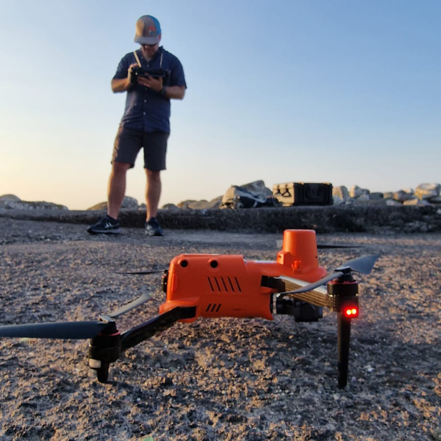
UNCREWED AERIAL VEHICLES
Uncrewed Aerial Vehicles (UAVs), commonly known as drones, are aircraft operated remotely without a pilot onboard. In coastal mapping, UAVs are equipped with advanced sensors and high-resolution cameras to capture detailed imagery and data of shorelines and coastal features. These aerial surveys provide precise, up-to-date insights into coastal erosion, habitat changes, and environmental dynamics. By offering efficient and accurate monitoring, UAVs play a crucial role in environmental management, disaster response, and scientific research, helping experts track and analyze coastal changes with unprecedented detail.
During the Summer School, the UNIMIB and Orthodrone research teams organized various field activities focused on drone-based data collection at multiple sites, including Aci Trezza, Lachea Island, and Mt. Etna. Students actively engaged in the entire UAV survey process, from planning and data acquisition to processing and analysis. In dedicated laboratory sessions, they explored the fundamentals of data processing using industry-standard software such as Agisoft Metashape and CloudCompare to visualize and analyze their collected data. This hands-on approach provided them with valuable practical experience and essential skills in drone-based surveying and data analysis.
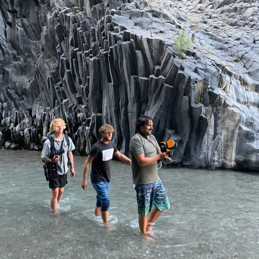
GEOSLAM
GeoSLAM is a state-of-the-art handheld laser scanner equipped with a LiDAR sensor, designed for rapid and accurate 3D mapping. Utilizing Simultaneous Localization and Mapping (SLAM) algorithms, it enables the acquisition of geo-referenced 3D point clouds, making it a powerful tool for a wide range of applications, including slope stability assessment, monitoring 3D geomorphic processes, forestry measurements, plant biomass estimation, urban planning, and underground mapping. This advanced system captures up to 300,000 points per second, with a maximum range of 100 meters and an accuracy of less than 3 cm. The output includes precisely aligned and colorized 3D point clouds, along with panoramic imagery sample points, offering detailed spatial information for analysis and visualization.
During the Etna Summer School, the UNIMIB research team conducted a GeoSLAM survey, actively involving all students in field data collection. The survey took place in the stunning Alcantara Gorges, a narrow canyon shaped by the erosion of steep columnar basalt walls.
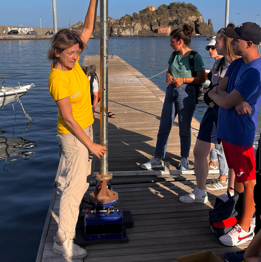
AMBIENT NOISE
Ambient noise measurement is a widely used geophysical technique to assess subsurface properties by analyzing naturally occurring seismic vibrations. This passive method relies on background seismic waves generated by natural or human activities, making it an efficient and non-invasive approach for site characterization. The horizontal-to-vertical spectral ratio (H/V) method, in particular, is commonly used to estimate the resonance frequency of the ground, which provides insight into subsurface layering and soil properties.
During the Summer School, we conducted H/V ambient noise measurements using a 1 Hz Lennartz 3-component sensor, connected to a Cityshark seismic station. The recordings, captured over 20 minutes, had a sampling rate of 200 Hz (with a 0.005 s sample interval). These data were then processed in the frequency domain to compute the horizontal-to-vertical spectral ratios, which allow for the identification of the ground's fundamental resonance frequency. This resonance frequency can provide valuable information for estimating the thickness of the upper soft soil layer.

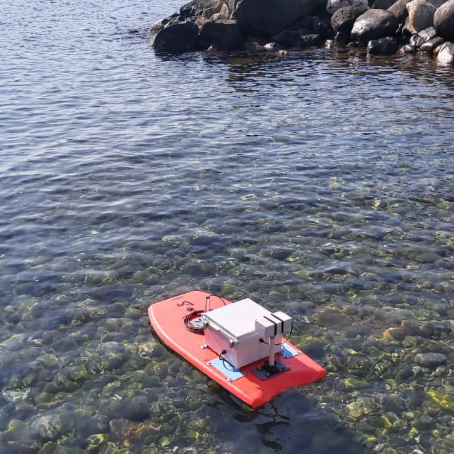
AUTHONOMOUS SURFACE VEHICLE
Autonomous Surface Vehicles (ASVs), are advanced waterborne platforms that operate without onboard crews. Equipped with AI, GPS, and various remote sensing technologies, they can function autonomously or via remote control. ASVs are widely used for hydrographic surveys, environmental monitoring, marine research, and offshore inspections. They efficiently collect real-time data, enabling safer and more cost-effective operations in hazardous environment or areas that are significantly remote or inaccessible for regular vessels. As technology advances, ASVs are becoming essential tools for sustainable and automated maritime applications.
During the Summer School, the ASV developed by Dr. Daniel Carlson was equipped with: a Positioning System (GPS) leading the autonomous navigation system and useful for data georeferencing; a Side Scan Sonar, an active sonar system used to image the seafloor and qualitatively investigate its nature; an IMU, a motion sensor used to register the motion of the vessel and correct the acquired data for the roll, pitch and heading biases. Participants had the opportunity to see this cutting-edge platform in action to collect backscatter data of the seafloor.
MULTIBEAM ECHOSOUNDER
The R2Sonic 2022 is a high-performance Multibeam Echosounder (MBES) designed for precise underwater mapping and surveying. Utilizing advanced sonar technology, it generates highly detailed 3D models of the seafloor. Its variable swath width capability allows users to adjust beam angles, optimizing coverage based on survey needs. Additional advanced features include real-time water column imaging, automated data processing, integrated data quality control tools, and an optional multispectral mode for enhanced analysis. Built with a rugged, compact design, the R2Sonic 2022 is ideal for deployment across various vessels and survey operations.
The surveys conducted on Geonautics coastal hydrographic vessel with the pole-mounted UNIMIB’s MBES, provided high resolution bathymetric data that unveiled the volcanic formation outcropping from the seafloor. Students were able to follow the MBES installation and initial setting, but due to limited space on board, they didn’t participate to the surveys. Nonetheless, in the dedicated laboratory sessions, students had the opportunity to carry hands-on activity on QPS Qimera for swath data processing and on QPS Fledermaus for data visualization. Such activities proved to the students the intimate interconnection occurring between the coastal and marine environments.
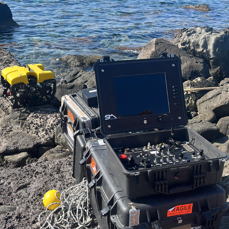
REMOTELY OPERATED VEHICLE
The future of ocean research and exploration is increasingly driven by robotics, with Remotely Operated Vehicles (ROVs) playing a crucial role. ROVs are uncrewed, tethered underwater robots controlled by operators from a surface vessel. Equipped with high-definition cameras, robotic arms, and advanced sensors, they enable scientists to explore depths and environments that are otherwise inaccessible to humans. They offer real-time control and intervention, making them ideal for deep-sea research and environmental monitoring. Their ability to operate continuously and with precision makes them indispensable tools for modern ocean exploration.
During the Summer School's dedicated field activity, participants had the unique opportunity not only to observe and learn about UNIMIB's SEAMOR Steelhead inspection-class ROV in action, but also to pilot it themselves. Due to its lightweight design, stability, and user-friendly flight controls, this ROV results simple to operate, providing students with the opportunity to gain practical experience in underwater exploration. By maneuvering the ROV, students were able to ground-truth acoustic data, visually confirming seafloor features and directly observing Aci Trezza’s peculiar seafloor morphology and its volcanic nature.
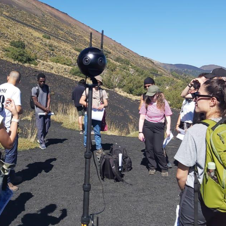
360° CAMERA
360° cameras are advanced tools that capture fully immersive imagery, allowing users to explore scenes from any angle. Using multiple ultra-wide lenses, they record spherical videos and photos, which are seamlessly stitched together for applications in VR experiences, virtual tours, education, and geospatial mapping. So far, this technology is most often used by real estate companies, the e-commerce sector and by GoogleStreetView for geospatial data. The opportunities for using 360° imagery for teaching in a virtual reality framework are endless and are evolving constantly. Indeed, they are becoming widely used in several fields, such as scientific research and environmental monitoring, offering new ways to document and interact with real-world environments.
During the Summer School, we utilized the Insta360 Pro 2, a professional-grade 360° camera equipped with six 4K lenses, capable of producing high-resolution 8K 360° footage. This cutting-edge technology enabled us to shoot videos and photos of the investigated research areas, and will allow us to create virtual tours contributing to deliverables such as a “virtual cruise” and an immersive guide for seamless land-to-sea geological modeling.